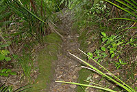

Old tracks like this one are found throughout Green Bay.

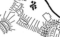
NZ Historic Places Trust site plan of Te Whau pa, 1981.

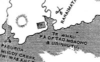
Judge F. D. Fenton's map showing Te Whau/Karaka pa.

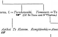
Judge F. D. Fenton's geneology of Waiohua and Te Taou, showing Ngati Whatua chief Apihai Te Kawau - who sold the Auckland District to the European colonialists - joining the two tribes.
from F. D. Fenton, Important Judgements 1866-1879 Delivered in the Compensation Courts and Native Land Courts, Orakei, Auckland, December 22, 1869.
E. M. Blaiklock, Ten Pounds An Acre, A. H. & A. W. Reed, 1965.
E. M. Blaiklock, Between The Valley And The Sea, The Dunmore Press, 1979.
Annette Brown, Lorraine Wilson and Rona Walker, The 1990 Blockhouse Bay Settlers' Handbook, Blockhouse Bay Historical Society, 1990.
B. W. Hayward and J. T. Diamond, Prehistoric Archaeological Sites of the Waitakere Ranges and West Auckland, New Zealand, Auckland Regional Authority, 1978.
F. D. Fenton, Important Judgements 1866-1879 Delivered in the Compensation Courts and Native Land Courts, Orakei, Auckland, December 22, 1869.
George Graham, Maori Place Names of Auckland compiled by David Simmons, In David Simmons, Maori Auckland, The Bush Press, Auckland, 1987.
R. C. J. Stone, From Tamaki-Makau-Rau To Auckland, Auckland University Press, 2001.
Bruce and Trixie Harvey, Waitakere Ranges - Nature, History, Culture. The Waitakere Ranges Protection Society Inc., 2006.
Waitangi Tribunal Research Rangahaua Whanui District Report 01 - Auckland.
One of the things E. M. Blaiklock writes about in the middle of the 20th century are the old tracks that passed through his parents farm, and along the cliffs to the various secluded bays on the Manukau coast. These tracks seem to have been in use for years - long before the arrival of Europeans:
"It was a padded footway with a surface of smooth hardened grey which always denotes a Maori track, polished to firm sterility by centuries of passing feet. Moss alone would grow there and when it was wet the grey clay was as slippery as ice. Such paths have never failed to interest me and this one was, I think, part of the great complex of tracks which led from the Waitemata to the Manukau in the Golden Age of Tamaki."
E. M. Blaiklock, Ten Pounds An Acre, A. H. & A. W. Reed, 1965.
"It ran, hard-padded clay, moss-grown at the edges, and hollowed down the middle by long years of rain, over the back road and the hill beyond, to a dent in the Manukau coastline, which we called Rocky Bay...
The track ran as straight as natural obstacles allowed to its harbourside destination, a last surviving remnant of a trail which may have begun on the other side of the isthmus. Auckland's Karangahape Road, I am assured, is on the line of a ridge top track of the Orakei tribesmen. They would make for the Western Springs, then with a line on some Titirangi summit come on along the line of the Great North Road, circle the top end of the Whau estuary and join the other east-west track which is Godley Road."
E. M. Blaiklock, Between The Valley And The Sea, The Dunmore Press, 1979.
A line drawn down Godley or Golf Roads on a modern street map intersects directly with One Tree Hill (Maungakiekie) - from where Waiohua and their ancestors ruled the region for hundreds of years until conquered by Ngati Whatua in about 1750. Likewise, it's possible that E. M. Blaiklock's old track could have been a secondary portage slightly further west than Te Whau, connecting the Rewarewa creek at New Lynn with the Manukau coast. The main track up to Titirangi through the Rahui Kahika reserve might also be a vestige of these times.
Te Whau was governed at Green Bay by twin pa on either side of the Manukau entrance. Whoever controlled these pa were gatekeepers across this part of the isthmus.
Most important was the eastern headland now called Te Whau point, occupying a commanding position overlooking the portage, Blockhouse Bay, and across the Manukau in all directions. As detailed in a New Zealand Historic Places Trust report in 1981, this pa was once terraced, with a large ditch that slowed access onto the headland. It is now greatly eroded. In its day it is estimated that about 200 people lived, worked, fought and died at Te Whau pa.
The other pa, Karaka, was on the western side of the portage, although less detailed archaeological evidence now remains to tell us much about it. Karaka trees are common around pa sites because of their edible berries - Green Bay was called Karaka Bay on early maps.
These pa appear on the map of Auckland prepared by Chief Judge Francis Dart Fenton in 1869 for the Native Land Court hearings, as part of his attempt to document the history of the isthmus and the Ngati Whatua claim at Orakei. They can also be seen on the edge of Hochstetter's 1859 map.
Early ethnographer George Graham's seminal collection of Maori place names in Auckland records names for geographical features right throughout the course of Te Whau - from the Manukau to the Waitemata across the isthmus:
"WAIROPA 'The slaves' water'. A channel in the Manukau Harbour off Karaka Bay. On the south side of the Mutukaraka sandbank.
MUTUKARAKA 'The end of the karaka'. A sand bank in the Manukau Harbour off Green Bay. Also Motukaraka, "Island of Karaka".
TE WHAU a shrub (Entelea aborescens). Tidal creek flowing into the Waitemata. Known as Whau Creek. The western headland off Blockhouse Bay, Manukau.
KARAKA Name of a tree. A little bay on Maukau harbour in the vicinity of Green Bay to the west thereof. Actually Green Bay itself.
WAITAHURANGI 'Fairy River'. A creek at the headwaters of the Whau creek on the western side.
TE KOTUITANGA 'The dovetailing'. A creek at the headwaters of the Whau Creek on the eastern side. Builders of canoe attacked when dovetailing canoe.
RANGIMATARIKI 'The day of the small spears'. Possibly name of battle. Also Rangi - sky; Matariki - Pleiades, a group of stars. The eastern headland of the Whau Creek.
MOTUMANAWA 'The island of the Manawa shrub'. A large island at the mouth of the Whau Creek. Or Heart Island. Pollen Island."
George Graham, Maori Place Names of Auckland compiled by David Simmons, In David Simmons, Maori Auckland, The Bush Press, Auckland, 1987.
Archaelogical evidence seems to suggest that all the ditch-bearing pa sites along the north Manukau coast may have originally been built when Ngati Awa controlled the whole area in the fifteenth and sixteenth centuries.
Ngati Whatua swept through Te Whau in 1750 on their way to defeat Kiwi Tamaki's Waiohua. After this defeat Ngati Whatua consecrated many of the major pa as tapu and left them unoccupied. However, they were documented using at least one of the Green Bay pa in 1837. It may well have been in use up to 1863, when all Maori who were not loyal to Queen Victoria were exiled to the Waikato and their waka destroyed during the Maori Land Wars, seriously curtailing Maori trade throughout the Manukau. The flat area behind Titirangi beach was allegedly used by local Maori up until about 1900.
