Ewen Cameron, Bruce Hayward, and Graeme Murdoch, A Field Guide to Auckland, Random House, 1997.
Department of Geology, University of Auckland - Geology of Auckland.
Te Ara: Encyclopedia of New Zealand.
Manukau Harbour Coastal Reserves draft management plan (Avondale/Mt Roskill) - Natural and physical environment.
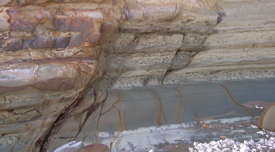
The clay that makes up most of the soil in my backyard was originally eroded from a huge ancestral northern land about 2 million years ago, and in progressive waves washed into the Waitamata basin. Looking at local Manukau coastal cliffs today you can see the way the sediment was deposited in layers. It's quite different to the volcanic aggregates further west, or the much younger Waitamata silt and clay down towards New Lynn.
The Manukau harbour also began to form when sand was carried down the Waikato river from eruptions in the Taupo and Rotorua region, together with iron sands washed around the coast from Taranaki.
Between 15 and 22 million years ago, a huge 50 kilometre-wide and 3 kilometre-high Waitakere volcano grew from the ocean about 20 kilometres west of the current west coast. The modern Waitakere Ranges are the greatly eroded remains of the eastern flanks of this monstrous volcano.
A huge subsidence on the south of the great northern land about 22 million years ago created the Waitamata basin and the Auckland region was flooded. 25 million years ago, the ancestral northern land was greatly enlarged as the Pacific plate slid underneath the Australian plate over a period of 5 million years, scraping off the eastern Pacific sea floor in the process.


